
It’s been a couple of years since I’ve posted here on my blog. Just wanted to put in my 2 cents about the severe weather event that occurred on April 26, 2016 and the OKC media’s role in preparing their viewers in the upcoming days prior to it. This post is more about the media and less about what went wrong with the severe weather event.
For almost a week before April 26, weather forecast models were hinting at a very robust, negatively tilted trough sweeping through the Southwest U.S., then lifting north through the Plains. Even I was impressed on how consistent both the Global Forecast System(GFS) and the European Centre for Medium-Range Weather Forecasts (ECMWF) forecast models were about Tuesday, April 26. Most, if not all, forecast models showed ample moisture(both surface and lower levels), energy (CAPE), and good shear.
Minus a couple of factors inhibiting discrete supercell development, it seemed most of the Central and Southern Plains were going to see a severe weather outbreak. Even short-range, high resolution models were predicting an explosive development of discrete supercells, especially in western/southwestern Oklahoma the morning of the event. However, it didn’t pan out the way most meteorologists thought it was going to.
If you look at the storm reports from the Storm Prediction Center (and these are all preliminary reports, with reports still pending), you can be the judge of whether SPC’s Moderate Risk and PDS Tornado Watch were verified. In my opinion, I think the Moderate outlook verified, but not sure about how the outlook categories were drawn.
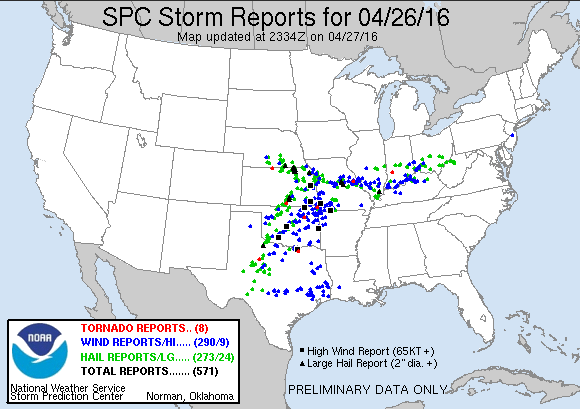
Tuesday, April 26, 2016 preliminary severe weather reports via SPC. Updates still pending.
The main thing I really want to talk about is the media’s, local especially, role in preparing and informing the public on upcoming severe weather. Here in the Oklahoma City TV market, it seems each station has their own language, scales, and “warnings” in preparation for a severe weather event, whether the severe risk is small or large. If you’re like me, you don’t just watch one news station. You’ll watch several stations to get an idea of who is saying what. If it were just news, inconsistencies would be somewhat tolerable, depending on their sources. However, for the weather, I feel it should be different! This has been a major problem for as long as I have been living in Oklahoma (and most likely before), but especially since 2013, after the Moore, OK tornado.
Take a look at the differences each TV station (minus KOKH) in Oklahoma City had leading up to April 26:
KFOR (Channel 4):
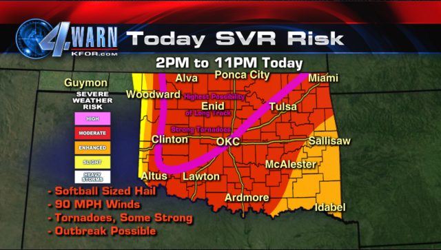
Via KFOR
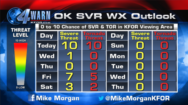
Via KFOR
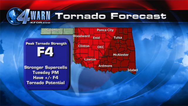
Via KFOR
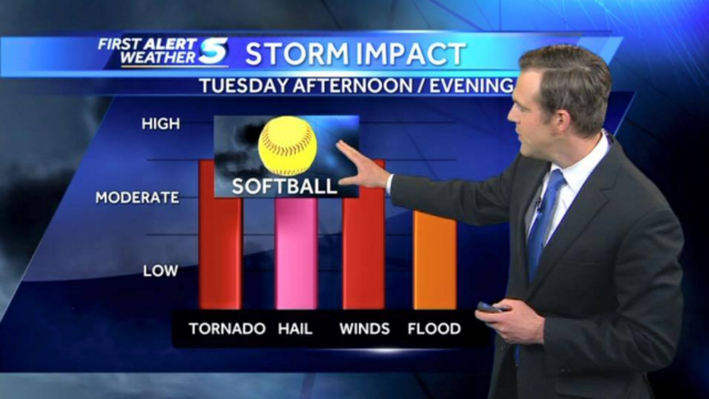
KWTV (News 9):
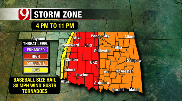
Via KWTV
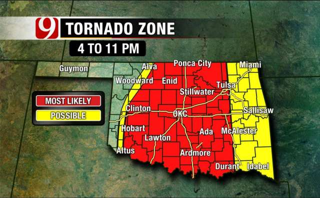
Via KWTV
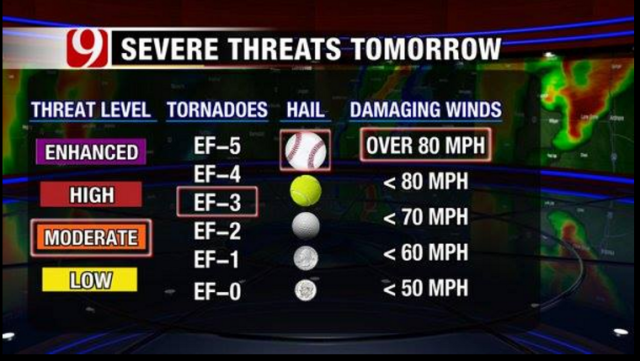
Via KWTV
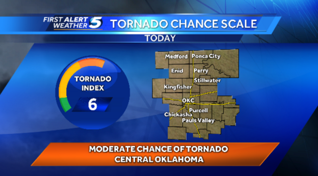
KOCO (Channel 5):
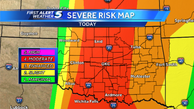
Via KOCO
Via KOCO
Via KOCO
Let’s forget about the accuracy of how each station did. Let’s also look past the critical mistakes (and there are a few for each station) that some of these graphics entail. You can easily see where the problem lies. Each station has its own “rating system” and tornado probabilities, none of which are consistent. To be fair, KOCO and KOKH (Fox 25) do a great job using SPC’s convective outlooks (Marginal, Slight, Enhanced, Moderate, High risks).
Here’s my solution(s) to this, and maybe you might disagree: each station be much more consistent with each other. This would likely mean a conference call each morning and/or afternoon and/or evening to discuss what each station should say and use as a graphic. I believe they should also be somewhat consistent with what the National Weather Service says, too. And I get it, these are competitive stations that will likely not easily agree to things, but shouldn’t the viewer’s safety be more important than ratings?
Also, I’m not so sure a rating system is a good idea. People love numbers. People also love percentages. If you say there’s a 6/10 chance of a tornado in a certain area, many people are going to think there’s a 60% chance of getting hit by a tornado. This is not what you should be telling people. Therefore, I think using numbers in scales is a bad idea, though I don’t really have another solution other than using colors instead of numbers. Maybe something similar to the terror threat scale? But even then, it has its flaws. I’m really not trying to criticize any station, but these things have been a problem for many, many years.
Questions? Concerns? Comments? Let me know what you think.


